AgroSol.html
Dorronsoro-Diaz C.1, Diez M.2, Sierra M.2, Dorronsoro B.3, Simon M.4, Dorronsoro-Fdez C.2
1 Instituto de Optica "Daza Valdes", CSIC. 28006 Madrid, España.
2 Departamento Edafologia y Química Agricola, Facultad de Ciencias, Universidad de Granada, 18002 Granada, España.
3 Departamento Lenguas y Ciencias de la Computacion, E.T.S.I. Informatica, Universidad de Malaga, 29071 Malaga, España.
4 Dpto. de Edafología y Química Agrícola. Universidad de Almería. 015117 Almeria. España.
Land evaluation is an applied classification system that assesses the capacity of the soil for its optimal use—that is, to derive maximum benefits with minimum degradation.
Different types of soils present widely different properties, and therefore the response to each use differs. Land evolution is based on the idea that this response is a function of these properties, and, hence, knowing these, we can predict the behaviour of the soil under a given use.
The study area
The study area is located at the south of the Baza city (Granada, Spain), situated at NW of the cartographic map 994.
The geological materials are carbonated: limestones and dolomites in the mountains; footslope and glacis coming from these mountains; marls and lime-marls in the hilly relieves; carbonate deposits in the river beds of the Hoya de Baza. The climate is semiarid with an average temperature of 14 ºC (with a high seasonal variation) and annual precipitations around 400 mm. The natural vegetation is rockrose type, with ilex and low density brushwood (esparto and thyme), many areas are foretasted by pine. The main crops in the area are cereals, with less area dedicated to olive-tree and almond. Irrigated lands appear surrounding the rivers, with vegetable gardens and fruit-trees.
The soils
The main soils in the study area are Leptosols (Lithic, Eutric, Mollic, Rendzic), Regosols (Eutric, Calcaric, Leptic), Fluvisols (Calcaric, Eutric), Solonchaks (Calcic, Haplic), Calcisols (Petric, Leptic, Luvic, Haplic), Cambisols (Calcaric, Haplic) and Luvisols (Chromic, Cutanic).
The application
This computer program shows how to evaluate soils for Land Capability according to the Land-capability-classification system of the USDA (Montgomery and Kieberg, 1965), but as politico-socio-economic criteria are not employed, the Soil Evaluation term proposed by Dorronsoro (2002) instead of Land Evaluation have been used. Soil evaluation represents the first step for land evaluation.
It is an application with educational purposes to introduce the students in the soil evaluation techniques.
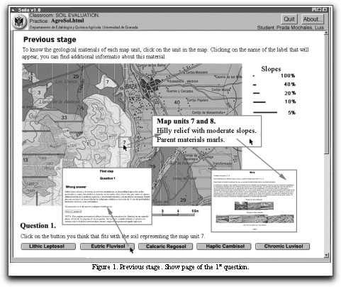
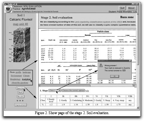
The program is organized in two stages. In the first stage three questions about the soils are established, their location and forming factors. In this previous stage bonus can be obtained to compensate for the possible mistakes in the final stage of the soil evaluation. In the second stage, for each soil, data are provided in relation to the general characteristics of the zone where the soil is located (climate and morphological as well as physico-chemical data) together with a photograph of the profile and landscape in question.
For the soil evaluation, a series of questions are posed concerning: 1) slope of the terrain; 2) soil depth; 3) rock content; 4) rock and gravel content; 5) drainage; 6) flood risk; 7) texture; 8) pH; 9) degree of base saturation; 10) carbonate content; 11) salt content; 12) climatic aridity; 13) frost risk; 14) degree of erosion (Figure 2).
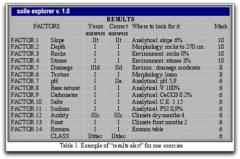
The program allows both the self-learning of the students as their self-evaluation. The highest score is 10 points, each wrong answer being penalized two points (Table 1).
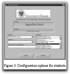
The structure of this program is multi-platform (PC, Mac, Linux, etc.); it is written in html/JavaScript. A specific high-security navigator (soile v.1.0) has been developed to examine students, by cancelling some non-desired options of the usual navigators (navigator menu, refresh of the page, access to the source, access of the historical, etc) and providing automatic recording of the results (Figure 3).
References
Dorronsoro, C. 2002. Soil evaluation. The role of the Soil Science in the Land Evaluation. Sustainble use and management of soils in arid and semiarid regions. SUMASS 2002.Cartagena (Murcia-Spain).Volume I. Edts.: A. Faz, R. Ortiz, A.R. Mermut. 106-128. Quaderna Editorial. Murcia.
Klingebiel, A.A. & Montgomery, P.H. 1961. Land capability classification. USDA Agricultural Handbook 210. US Government Printing Office, Washington, DC.
Lozano Cantero, F.J. 1990. "Estudio edáfico de la zona de Baza (994) Balance de erosión y degradación". Departamento de Edafología y Química Agrícola. Universidad de Granada. Tesis Doctoral.