SuitMap.html
Martin F.*, Dorronsoro B.**, Martinez F.J.*, Dorronsoro-Diaz C.***, Lozano J.****, Dorronsoro-Fdez C.*
* Departamento
Edafologia y Química
Agricola, Facultad de Ciencias, Universidad de Granada, 18002 Granada, España.
**
Departamento Lenguas y Ciencias de la Computacion,
E.T.S.I. Informatica, Universidad de Malaga, 29071 Malaga, España.
***
Instituto de Optica "Daza Valdes", CSIC.
28006 Madrid, España.
**** Dpto. de
Edafología y Química
Agrícola.
Universidad de Almería. 015117 Almeria. España.
As is well known, soil evaluation represents the first step for appropriate land use, enabling conservation with minimum degradation.
This computer program teaches soil evaluation for specific purposes (land suitability) according to the A framework for land evaluation (FAO, 1976). As politic-socio-economic criteria are not employed, the Soil Evaluation term proposed by Dorronsoro (2002) instead of Land Evaluation have been used.
The soils evaluated are: Eutric Leptosol, Calcaric Regosol, Calcaric Fluvisol, Dystric Arenosol, Haplic Solonchak, Calcic Vertisol, Haplic Kastanozem, Luvic Phaeozem, Petric Calcisol, Haplic Umbrisol, Haplic Cambisol and Chromic Luvisol.
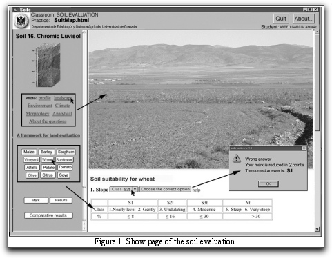
For each soil, data are provided in relation to the general characteristics of the zone where the soil is located (climate and morphological as well as physic-chemical data) together with a photograph of the profile and landscape in question (Figure 1).
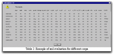
The evaluation is made for the following crops: wheat, barley, sorghum, maize, alfalfa, soy, sunflower, potato, tomato, olive, and citrus.
The soil evaluation is made after answering a total of 20 questions on soil characteristics: 1) slope of the terrain; 2) soil depth; 3) rock content; 4) stone content; 5) gravel content; 6) drainage; 7) Organic carbon; 8) texture of the surface horizon; 9) texture of the subsurface horizon; 10) pH of the surface horizon ; 11) pH of the subsurface horizon; 12) degree of base saturation of the subsurface horizon; 13) base saturation degree of the subsurface horizon; 14) carbonate content of the surface horizon; 15) carbonate content of the subsurface horizon; 16) salt content of the surface horizon; 17) salt content of the subsurface horizon; 18) sodium content of the surface horizon; 19) sodium content of the subsurface horizon; 20) degree of erosion.
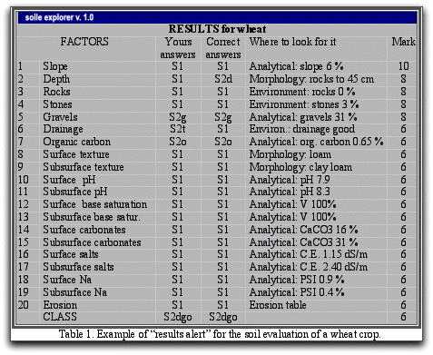
The application allows both the self-learning of the students as their self-evaluation. The highest score is 10 points, each wrong answer being penalized two points. In table 1 appear an information window corresponding to the soil evaluation of a wheat crop and in table 2 the information regarding to all crops evaluated in one exercise is shown.
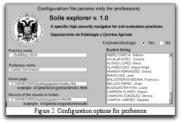
The structure of this application is multi-platform (PC, Mac, Linux, etc.); it is written in html/JavaScript. A specific high-security navigator (soile v. 1.0) has been developed to examine students, by cancelling some non-desired options of the usual navigators (navigator menu, refresh of the page, access to the source, access of the historical, etc) and providing automatic recording of the results (Figure 2).
References
Dorronsoro, C. 2002. Soil evaluation. The role of the Soil Science in the Land Evaluation. Sustainble use and management of soils in arid and semiarid regions. SUMASS 2002.Cartagena (Murcia-Spain).Volume I. Edts.: A. Faz, R. Ortiz, A.R. Mermut. 106-128. Quaderna Editorial. Murcia.
FAO 1976. A framework for land evaluation. Soils Bulletin 32. Food and Agriculture Organization of the United Nations, Rome, Italy.